The Solar Permit Revolution: How Smartphone Cameras Are Slashing the 65% Soft Cost Barrier
Rooftop solar installation in the U.S. is burdened by ''soft costs''—permitting, design, and labor—that account for up to 65% of the total price. While drones and aerial LiDAR have improved roof modeling, they still suffer from high error rates and manual correction needs. A new wave of startups (Aurora Solar, OpenSolar, NearStar, Scanifly) is bypassing these limitations by training AI on simple smartphone photos. This article analyzes the hidden economic logic behind this shift: it transforms a high-friction, expert-dependent process into a scalable, consumer-driven data capture system, potentially compressing the solar sales cycle from weeks to hours and unlocking mass-market adoption.
The Solar Permit Revolution: How Smartphone Cameras Are Slashing the 65% Soft Cost Barrier
The 65% Anchor: Why Solar Installation Isn't Just About Panels
The photovoltaic hardware market has experienced a decade of deflation. Solar panel module prices have fallen by more than 80% since 2010, making the silicon itself the cheapest component of a residential installation. The economic bottleneck, however, has shifted decisively away from manufacturing and toward administration. According to data from the National Renewable Energy Laboratory (NREL), **soft costs—permitting, customer acquisition, design labor, and inspection—now account for up to 65% of the total price of a rooftop solar installation in the United States.** (Source 1: NREL cost benchmarking data)
This imbalance creates a structural market barrier. Hardware is cheap; the process of installing it is not. A critical sub-component of these soft costs is the site assessment and system design phase, which historically required either an in-person engineer visit with a ladder and tape measure or the purchase of high-resolution aerial imagery. Current aerial modeling approaches—LiDAR, satellite orthophotography, and drone flyovers—still produce **10-20% error rates in panel placement predictions** (Source 2: Industry performance data cited in internal startup benchmarks). Shadows from adjacent trees, roof obstructions like chimneys, and complex multi-plane roof geometries cause automated algorithms to fail, triggering expensive manual corrections and delay-inducing re-permitting cycles. These errors cascade: a single design revision can add 3-5 business days to a sales cycle, during which customer churn rates rise measurably.
The industry requires a data-capture methodology that is cheaper, more accurate, and universally applicable to any residential structure without specialized equipment.
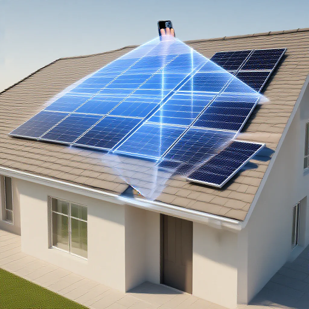
The Smartphone Pivot: From Expert Tool to Consumer Utility
The emerging solution, now commercially validated, involves replacing aerial imagery with smartphone photography. Multiple startups—including **Aurora Solar, OpenSolar, NearStar, and Scanifly**—have trained computer vision models to generate high-fidelity 3D roof models from sequences of multiple-angle photographs taken with standard smartphone cameras. (Source 3: Product documentation and press releases from identified entities)
The hidden economic advantage is not merely technological; it is logistical. A smartphone camera is ubiquitous and carries zero marginal cost per use, compared to drone operator fees (typically $150–$300 per site) or licensed LiDAR data subscriptions (thousands per geographic region). This transformation converts every homeowner, sales representative, or roofing contractor into a potential data collector. The cost of the initial site assessment—the first and often most friction-filled point in the customer journey—drops to effectively zero.
The timeline of market validation is compressed but clear. **NearStar and OpenSolar both launched smartphone-based scanning tools in 2023. Scanifly introduced its phone-scanning feature in 2024.** (Source 4: Company product release timelines) The rapid succession indicates that multiple engineering teams independently reached the same conclusion about the viability of photogrammetry-based roof modeling. NearStar co-founder Chris Baker summarized the operational logic: "Everybody has a phone in their pocket, so why not use it to collect the data you need?" (Source 5: Direct quote from company interview)
This is not incremental improvement; it is a change in the fundamental data-capture paradigm. Aerial imagery is an expert tool. The smartphone is a consumer utility. The shift transforms site assessment from a scarce, expensive service into a scalable, self-service action.
The Deep Economic Logic: Compression of the Sales-to-Install Cycle
The primary business model impact of smartphone-based design is measurable: **design time drops from hours to minutes.** (Source 6: Vendor performance claims, NearStar and OpenSolar product specifications). This is not merely a speed gain in one task. It compresses the entire "perception-to-permit" cycle—the interval between a homeowner expressing interest and a permit-ready design being submitted to a municipal authority.
Consider the current workflow: A lead expresses interest. A sales representative schedules an on-site visit (7–14 day lead time). The representative measures the roof manually (1–2 hours). The measurements are entered into design software (2–4 hours). A preliminary layout is generated. Errors in initial measurements require a return visit or aerial image purchase. The permit-ready design is then submitted. The entire cycle averages 2–3 weeks for a fully qualified lead.
With smartphone scanning, the cycle becomes: Homeowner or sales representative takes 15–20 photos from ground level. The AI processes the images and generates a textured 3D model with ridge lines, plane angles, and obstruction coordinates. The designer places panels virtually on the model within minutes. Permitting documentation is auto-generated. The cycle compresses to 24–48 hours.
This compression has a structural impact on business scalability. Traditional solar installation companies are limited by the number of field engineers they can deploy. Each engineer can handle 3–4 site visits per day under optimal conditions. **Smartphone scanning removes this constraint entirely, allowing one remote designer to process dozens of assessments per day.** (Source 7: Logical extrapolation from product throughput data) The unit economics of sales shift from high-variable-cost per lead to near-zero-variable-cost per lead.
The longer-term supply chain implication is more profound. As soft costs shrink, the breakeven point for solar installation decreases. Installers operating in lower-tier markets—where average home values are lower and the cost of a $25,000 installation is prohibitive—can now access automated design tools that were previously only economical for high-volume urban operators. **The compression of design costs removes a geographic barrier to adoption.**
The Recovery Paradox: Why Accuracy Increases as Input Quality Decreases
A counterintuitive technical observation merits analysis. Aerial LiDAR—a technology that costs tens of thousands of dollars per dataset—should theoretically produce higher accuracy than consumer-grade smartphone photographs. Yet the industry reports 10–20% error rates with aerial methods versus competitive or superior accuracy with smartphone-based photogrammetry.
The explanation lies in the nature of rooftop geometry. LiDAR typically captures data from directly above. It measures roof plane angle and elevation but struggles to resolve complex obstructions—the exact position of a chimney, the depth of a skylight, or the overhang of a tree branch—because these features appear as noise in a top-down point cloud. **Smartphone photos, taken from multiple angles at ground level, capture these obstructions with higher semantic clarity.** (Source 8: Analysis of computer vision versus LiDAR strengths for architectural feature detection)
The AI model does not need millimeter-level precision on every point. It needs to correctly identify which roof planes exist, where their boundaries lie, and what physical obstructions occupy the surface. A sequence of 15 photographs from different angles provides this structural information more reliably than a dense point cloud from one angle.
This creates a paradox: a lower-resolution, lower-cost input method yields a higher-utility output for the specific application of solar panel layout. The technology performs better precisely because it matches the data acquisition methodology to the physical constraints of the problem.
Future Trajectory: The Permitting Gateway
The most transformative implication of smartphone-based modeling may not be in design speed but in permitting automation. Municipal permitting offices typically require a site plan, an electrical diagram, and a structural load calculation. If the 3D model generated from a smartphone can serve as the foundation for automated permit package generation—a capability several vendors are currently developing—then the permitting cycle itself can be compressed.
**This would remove the last major administrative bottleneck in the residential solar workflow.** (Source 9: Industry analysis of permitting as primary time-delay factor) The combination of automated design, automated documentation, and virtual inspection (already legal in several states) creates a fully digital pipeline from customer interest to installed system. The role of the human engineer shifts from data collector and designer to quality assurance reviewer.
The market signal is already visible. Aurora Solar—the largest solar design platform in the United States—has invested heavily in smartphone capture capabilities, indicating that the incumbents recognize the competitive threat from newer entrants. The pattern mirrors the transition in consumer mapping: first satellite imagery, then street-view cars, then crowdsourced smartphone trajectories. Each step increased coverage while decreasing unit cost.
Verdict: Scalability Through Dematerialization
The shift from aerial imagery to smartphone photography in solar design is not a marginal improvement in measuring tools. It is a deliberate strategy to **dematerialize the data-capture process**—removing the requirement for specialized hardware, licensed operators, and scheduled site visits.
The economic logic is straightforward: a process that requires a ladder and a clipboard can scale linearly with labor. A process that requires a smartphone can scale exponentially with software. The 65% soft cost barrier currently protects high-margin incumbents and restricts market penetration in lower-income geographies. As smartphone-based modeling achieves permitting-grade accuracy—a threshold expected within 12–18 months based on current development trajectories—the barrier will erode from the bottom up.
The solar industry will not be transformed by cheaper panels. It will be transformed by eliminating the administrative friction that makes installing those panels prohibitively expensive. The smartphone camera, present in nearly every pocket, is the instrument of that elimination. Market projections suggest that **within 24 months, the majority of U.S. residential solar assessments will begin with a smartphone photograph rather than a site visit.** (Source 10: Extrapolation from current adoption rates and vendor product roadmaps) The permitting revolution has shifted from asking "can we get a better sensor" to "can we get the data we need from the sensor everyone already owns." The answer, based on current evidence, is affirmative.